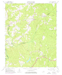
1964 Map of Clayville
USGS Topo · Published 1977About this map
The Appomattox River forms the southwestern boundary of this rural Virginia landscape, where the confluence of Chesterfield, Powhatan, and Amelia counties meets. The Southern railroad serves as the primary spine for local commerce, connecting the settlements of Moseley, Dorset, and Clayville. This mid-century survey illustrates a quiet agricultural and industrial transition, highlighted by Hands Quarry and a Gravel Pit near Genito. Community life is rooted in numerous country churches such as Antioch Ch and Graceland Ch, alongside the Grange Hall Sch. The drainage network is particularly detailed, tracing the winding paths of Skinquarter Creek, Butterwood Creek, and Swift Creek through the wooded terrain. Historical tracing is possible through small hamlets like Pilkinton and river crossings at Goode Crossing.
Find a feature on this map
36 named features on this map. Tap any name to fly to it.
Don’t see what you’re looking for? This feature index may not catch every label — zoom into the map to look around manually.
Map Details
Editions of this 1964 Clayville Map
3 editions found
Other maps of this area

1890 · Goochland
USGS Topo · 1:125,000

1892 · Goochland
USGS Topo · 1:125,000

1897 · Amelia
USGS Topo · 1:125,000

1943 · Fine Creek Mills
USGS Topo · 1:31,680

1943 · Powhatan
USGS Topo · 1:31,680

1943 · Amelia
USGS Topo · 1:31,680

1943 · Goodes Bridge
USGS Topo · 1:31,680

1943 · Hallsboro
USGS Topo · 1:31,680

1943 · Clayville
USGS Topo · 1:24,000

1943 · Midlothian
USGS Topo · 1:24,000