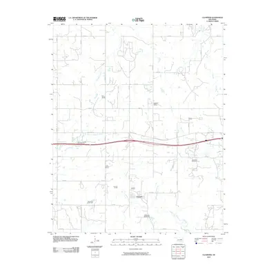
2010 Map of Clearview
USGS Topo · Published 2010About this map
Clearview is situated in the southeastern portion of this map, serving as a central point in a landscape defined by its energy history. The area is heavily marked by industrial activity, including the Clearview Oil Field and the Northwest Clearview Oil and Gas Field. These extractive sites, alongside the East Okemah Oil Field and Deaner Oil Field, reveal a region shaped by petroleum development throughout the twentieth century. The terrain is drained by several meandering waterways such as Alabama Creek, Philadelphia Creek, and Bad Creek, which are intercepted by several unnamed reservoirs like Oknoname 107026 Dam. Local history is anchored by the Clearview Cemetery, providing a genealogical focal point for the community. The map also shows the transition of transportation, where Old US Hwy 62 still parallels the modern highway route.
Find a feature on this map
36 named features on this map. Tap any name to fly to it.
Don’t see what you’re looking for? This feature index may not catch every label — zoom into the map to look around manually.
Map Details
Editions of this 2010 Clearview Map
This is the sole edition of this map. No revisions or reprints were ever made.
Other maps of this area

1900 · Wewoka
USGS Topo · 1:125,000

1901 · Nuyaka
USGS Topo · 1:125,000

1954 · Oklahoma City
USGS Topo · 1:250,000

1957 · Oklahoma City
USGS Topo · 1:250,000

1963 · Oklahoma City
USGS Topo · 1:250,000
1967 · Pharoah
USGS Topo · 1:24,000

1967 · Okemah SE
USGS Topo · 1:24,000

1967 · Weleetka
USGS Topo · 1:24,000

1967 · Okemah
USGS Topo · 1:24,000
1967 · Clearview
USGS Topo · 1:24,000