
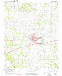
1967 Map of Okemah
USGS Topo · Published 1968About this map
Okemah serves as the focal point of this Okfuskee County survey, revealing a mid-century town structure defined by its civic and educational institutions. The residential and commercial blocks are anchored by the Courthouse, Po, and several primary schools, including Lincoln Sch and Noble Sch. The town's infrastructure at this time included the Okemah Airport and an active Drive-in Theater on the eastern periphery. Surrounding the town, the landscape reflects a transition from agricultural use to heavy industrial development, as evidenced by the Northwest Okemah Oil and Gas Field and numerous Oil Wells. In the northern section, the small communities of Morse and Castle sit near Buckeye Creek, while the southern border is defined by the Canadian River and the prominent Hickory Ridge. Genealogists will find significant value in the documentation of several rural burial sites, such as Highland Cem and the Green Leaf Ch Cem.
Find a feature on this map
36 named features on this map. Tap any name to fly to it.
Don’t see what you’re looking for? This feature index may not catch every label — zoom into the map to look around manually.
Map Details
Editions of this 1967 Okemah Map
2 editions found
Other maps of this area

1900 · Wewoka
USGS Topo · 1:125,000

1901 · Nuyaka
USGS Topo · 1:125,000

1954 · Oklahoma City
USGS Topo · 1:250,000

1957 · Oklahoma City
USGS Topo · 1:250,000

1963 · Oklahoma City
USGS Topo · 1:250,000

1967 · Cromwell
USGS Topo · 1:24,000

1967 · Okemah SE
USGS Topo · 1:24,000

1967 · Weleetka
USGS Topo · 1:24,000

1967 · Boley
USGS Topo · 1:24,000
1967 · Clearview
USGS Topo · 1:24,000