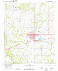
1967 Map of Okemah
USGS Topo · Published 1979About this map
Okemah serves as the central hub in this mid-century Oklahoma landscape, defined by an extensive patchwork of energy production and traditional infrastructure. The town itself is densely mapped with essential civic landmarks including the Courthouse, Hospital, and Lincoln Sch. Beyond the residential blocks, the surrounding countryside is dominated by vast oil and gas operations, such as the Northwest Okemah Oil and Gas Field and Midwest Oil and Gas Field. These energy-rich zones are interspersed with local history markers, including several rural burying grounds like Ebenezer Cem and Green Leaf Ch Cem. Transport and industry are further marked by an Old Railroad Grade and the Okemah Airport situated near Airport Lake. The southern boundary is established by the winding course of the North Canadian River near Hickory Ridge, illustrating the relationship between the region's natural waterways and its industrial development.
Find a feature on this map
37 named features on this map. Tap any name to fly to it.
Don’t see what you’re looking for? This feature index may not catch every label — zoom into the map to look around manually.
Map Details
Editions of this 1967 Okemah Map
2 editions found
Other maps of this area

1900 · Wewoka
USGS Topo · 1:125,000

1901 · Nuyaka
USGS Topo · 1:125,000

1954 · Oklahoma City
USGS Topo · 1:250,000

1957 · Oklahoma City
USGS Topo · 1:250,000

1963 · Oklahoma City
USGS Topo · 1:250,000

1967 · Cromwell
USGS Topo · 1:24,000

1967 · Okemah SE
USGS Topo · 1:24,000

1967 · Weleetka
USGS Topo · 1:24,000

1967 · Okemah
USGS Topo · 1:24,000

1967 · Boley
USGS Topo · 1:24,000