
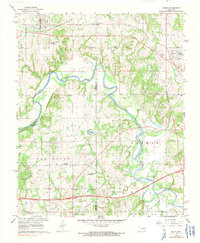
1967 Map of Boley
USGS Topo · Published 1968About this map
Boley stands as the primary settlement in this late-1960s survey of the Oklahoma landscape, positioned near the Old Railroad Grade and the Boley School for Boys. The map documents a rural transition where the North Canadian River winds through the central terrain, dividing the county lines of Seminole and Okfuskee. The region is marked by its community institutions, from the Schoolton area to numerous country churches including St Emmanuel Ch, Arbeka Ch, and Pigeon Roost Ch.
Find a feature on this map
41 named features on this map. Tap any name to fly to it.
Don’t see what you’re looking for? This feature index may not catch every label — zoom into the map to look around manually.
Map Details
Editions of this 1967 Boley Map
2 editions found
Other maps of this area

1896 · Seminole and Prague
USGS Topo · 1:125,000

1900 · Wewoka
USGS Topo · 1:125,000

1901 · Nuyaka
USGS Topo · 1:125,000

1929 · Stroud
USGS Topo · 1:62,500

1932 · Stroud
USGS Topo · 1:62,500

1954 · Oklahoma City
USGS Topo · 1:250,000

1957 · Oklahoma City
USGS Topo · 1:250,000

1963 · Oklahoma City
USGS Topo · 1:250,000

1967 · Cromwell
USGS Topo · 1:24,000

1967 · Prague NE
USGS Topo · 1:24,000