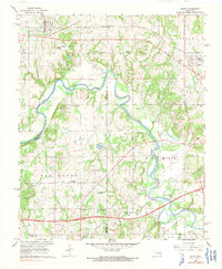
1967 Map of Boley
USGS Topo · Published 1991About this map
The North Canadian River meanders through Okfuskee and Seminole Counties, framing a landscape defined by small rural communities and educational institutions. The town of Boley stands as a significant cultural center in the northwest, supported by its namesake Boley Cem and the nearby Boley School for Boys. To the east, the settlement of Castle and the smaller community of Schoolton are connected by a network of country roads and an Old Railroad Grade that speaks to the area's earlier transportation history.
Find a feature on this map
42 named features on this map. Tap any name to fly to it.
Don’t see what you’re looking for? This feature index may not catch every label — zoom into the map to look around manually.
Map Details
Editions of this 1967 Boley Map
2 editions found

Other maps of this area

1896 · Seminole and Prague
USGS Topo · 1:125,000

1900 · Wewoka
USGS Topo · 1:125,000

1901 · Nuyaka
USGS Topo · 1:125,000

1929 · Stroud
USGS Topo · 1:62,500

1932 · Stroud
USGS Topo · 1:62,500

1954 · Oklahoma City
USGS Topo · 1:250,000

1957 · Oklahoma City
USGS Topo · 1:250,000

1963 · Oklahoma City
USGS Topo · 1:250,000

1967 · Cromwell
USGS Topo · 1:24,000

1967 · Prague NE
USGS Topo · 1:24,000