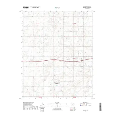
2018 Map of Clearview
USGS Topo · Published 2018About this map
Clearview serves as the focal point of this Okfuskee County landscape, where the local road network centers on Main St. The town's historical geography is deeply tied to its local cemeteries, with both French Cem and Clearview Cem located just north of the residential core. This 2018 survey reveals a terrain defined by an intricate web of drainages including Alabama Cr and Philadelphia Cr, which weave between the section lines of the Public Land Survey System. The transition of regional transit is evident in the presence of Old US Hwy 62, which runs parallel to the modern interstate corridor. Genealogists and local historians can use this map to pinpoint exact burial locations and trace the development of rural roads like E1120 Rd and N3840 Rd as they relate to the traditional township and range boundaries of the Oklahoma territory.
Find a feature on this map
36 named features on this map. Tap any name to fly to it.
Don’t see what you’re looking for? This feature index may not catch every label — zoom into the map to look around manually.
Map Details
Editions of this 2018 Clearview Map
This is the sole edition of this map. No revisions or reprints were ever made.
Other maps of this area

1900 · Wewoka
USGS Topo · 1:125,000

1901 · Nuyaka
USGS Topo · 1:125,000

1954 · Oklahoma City
USGS Topo · 1:250,000

1957 · Oklahoma City
USGS Topo · 1:250,000

1963 · Oklahoma City
USGS Topo · 1:250,000
1967 · Pharoah
USGS Topo · 1:24,000

1967 · Okemah SE
USGS Topo · 1:24,000

1967 · Weleetka
USGS Topo · 1:24,000

1967 · Okemah
USGS Topo · 1:24,000
1967 · Clearview
USGS Topo · 1:24,000