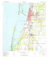
1943 Map of Clearwater
USGS Topo · Published 1961About this map
The growing city of Clearwater and its surrounding coastal communities are captured here in the midst of the Second World War. The landscape shows a region transitioning from its agricultural and maritime roots toward modern development, with the Clearwater Causeway connecting the mainland to Clearwater Beach Island. Inland, the transportation network is defined by the Seaboard Air Line and Atlantic Coast Line railroads, which served the small communities of Baskin, Anona, and Walsingham.
Find a feature on this map
59 named features on this map. Tap any name to fly to it.
Don’t see what you’re looking for? This feature index may not catch every label — zoom into the map to look around manually.
Map Details
Editions of this 1943 Clearwater Map
3 editions found
Other maps of this area

1921 · Sand Key
USGS Topo · 1:62,500

1921 · St Petersburg
USGS Topo · 1:62,500

1943 · St Petersburg
USGS Topo · 1:31,680

1943 · Bay Pines
USGS Topo · 1:31,680

1943 · Safety Harbor
USGS Topo · 1:31,680

1943 · Dunedin
USGS Topo · 1:31,680

1943 · Clearwater
USGS Topo · 1:24,000

1943 · Oldsmar
USGS Topo · 1:24,000

1944 · Oldsmar
USGS Topo · 1:31,680

1947 · St Petersburg
USGS Topo · 1:25,000