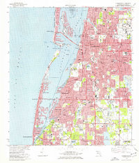
1974 Map of Clearwater
USGS Topo · Published 1976About this map
Clearwater and its neighboring beach communities are shown during a period of significant suburban infill and infrastructure growth. This coastal landscape is dominated by the complex relationship between the mainland and the barrier islands, connected by the Memorial Causeway and Belleair Causeway. A notable industrial presence is the U S Reservation Pinellas Plant (Atomic Energy Commission) in the southeast, contrasting with the leisure-oriented developments and numerous golf courses. The map records a dense network of local institutions, including the Rousseau Pioneer Cem and various parochial and public schools like St Cecelias Sch and Lakeview Jr Academy. Along McKay Creek, the transition from residential areas to tidal flats and the Intracoastal Waterway highlights the region's mid-century maritime and residential expansion.
Find a feature on this map
97 named features on this map. Tap any name to fly to it.
Don’t see what you’re looking for? This feature index may not catch every label — zoom into the map to look around manually.
Map Details
Editions of this 1974 Clearwater Map
2 editions found
Other maps of this area

1921 · Sand Key
USGS Topo · 1:62,500

1921 · St Petersburg
USGS Topo · 1:62,500

1943 · St Petersburg
USGS Topo · 1:31,680

1943 · Bay Pines
USGS Topo · 1:31,680

1943 · Safety Harbor
USGS Topo · 1:31,680

1943 · Dunedin
USGS Topo · 1:31,680

1943 · Clearwater
USGS Topo · 1:24,000

1943 · Oldsmar
USGS Topo · 1:24,000

1944 · Oldsmar
USGS Topo · 1:31,680

1947 · St Petersburg
USGS Topo · 1:25,000