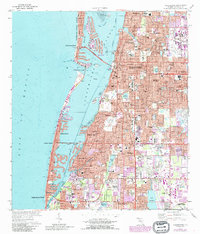
1974 Map of Clearwater
USGS Topo · Published 1987About this map
Clearwater and its surrounding coastal communities show the intense mid-century development of the Pinellas Peninsula, where intricate finger canals and seawalls have reshaped the shoreline along Clearwater Harbor. This 1974 survey, revised with 1980s data, documents the urban expansion of Dunedin, Largo, and the barrier islands from Clearwater Beach to Indian Rocks Beach. The map highlights the area's infrastructure and community life, from the Plant Hospital and Courthouse in the city center to suburban anchors like Anona Sch and Fuguitt Sch. A significant industrial presence is noted at the U S Reservation Pinellas Plant in the southeast. Cultural and historic sites are also preserved, including the Rousseau Pioneer Cem and numerous parish churches such as St Pauls Ch, providing essential reference points for genealogists and local historians.
Find a feature on this map
84 named features on this map. Tap any name to fly to it.
Don’t see what you’re looking for? This feature index may not catch every label — zoom into the map to look around manually.
Map Details
Editions of this 1974 Clearwater Map
2 editions found
Other maps of this area

1921 · Sand Key
USGS Topo · 1:62,500

1921 · St Petersburg
USGS Topo · 1:62,500

1943 · St Petersburg
USGS Topo · 1:31,680

1943 · Bay Pines
USGS Topo · 1:31,680

1943 · Safety Harbor
USGS Topo · 1:31,680

1943 · Dunedin
USGS Topo · 1:31,680

1943 · Clearwater
USGS Topo · 1:24,000

1943 · Oldsmar
USGS Topo · 1:24,000

1944 · Oldsmar
USGS Topo · 1:31,680

1947 · St Petersburg
USGS Topo · 1:25,000