
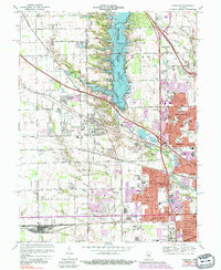
1967 Map of Clermont
USGS Topo · Published 1981About this map
Eagle Creek Reservoir dominates the central landscape of this western Marion County survey, reflecting a period of significant infrastructure development and suburban expansion. The reservoir is anchored by the Eagle Creek Dam and bordered by the sprawling Eagle Creek Park, illustrating the mid-century transformation of the local watershed. To the west, the Indianapolis Raceway Park and the Speedway Airport highlight the region's enduring connection to automotive and aviation culture.
Find a feature on this map
95 named features on this map. Tap any name to fly to it.
Don’t see what you’re looking for? This feature index may not catch every label — zoom into the map to look around manually.
Map Details
Editions of this 1967 Clermont Map
3 editions found

Other maps of this area

1948 · Maywood
USGS Topo · 1:24,000

1948 · Indianapolis West
USGS Topo · 1:24,000

1952 · Carmel
USGS Topo · 1:24,000

1953 · Bridgeport
USGS Topo · 1:24,000

1953 · Fayette
USGS Topo · 1:24,000

1953 · Brownsburg
USGS Topo · 1:24,000

1953 · Zionsville
USGS Topo · 1:24,000

1953 · Plainfield
USGS Topo · 1:24,000

1953 · Clermont
USGS Topo · 1:24,000

1953 · Indianapolis
USGS Topo · 1:250,000