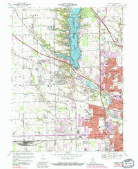
1967 Map of Clermont
USGS Topo · Published 1988About this map
Eagle Creek Reservoir dominates the center of this landscape on the western edge of Indianapolis, showing the area just as the suburban and industrial expansion of the late 1960s was taking hold. The transition from rural Hendricks and Marion counties to an urbanizing network is evident in the residential additions like Farley's Addition and Chapel Hill, which sit in contrast to the older crossroads character of Clermont. Large-scale infrastructure projects of the era are prominent, including the Eagle Creek Dam, the Big Four Yard rail complex to the south, and the expansive Indianapolis Raceway Park.
Find a feature on this map
113 named features on this map. Tap any name to fly to it.
Don’t see what you’re looking for? This feature index may not catch every label — zoom into the map to look around manually.
Map Details
Editions of this 1967 Clermont Map
3 editions found
Other maps of this area

1948 · Maywood
USGS Topo · 1:24,000

1948 · Indianapolis West
USGS Topo · 1:24,000

1952 · Carmel
USGS Topo · 1:24,000

1953 · Bridgeport
USGS Topo · 1:24,000

1953 · Fayette
USGS Topo · 1:24,000

1953 · Brownsburg
USGS Topo · 1:24,000

1953 · Zionsville
USGS Topo · 1:24,000

1953 · Plainfield
USGS Topo · 1:24,000

1953 · Clermont
USGS Topo · 1:24,000

1953 · Indianapolis
USGS Topo · 1:250,000