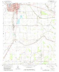
1966 Map of Cleveland
USGS Topo · Published 1984About this map
The delta community of Cleveland serves as a vibrant hub of education and transport in the mid-1960s, anchored by the campus of Delta State College and the University. This landscape is deeply defined by its water management and agricultural infrastructure, where the Illinois Central railroad runs parallel to the winding course of Jones Bayou. The town's grid expands toward Firemans Park and East Side Park, while the outskirts are punctuated by specialized land uses including a Fish Farm and multiple Sewage Disposal Ponds.
Find a feature on this map
47 named features on this map. Tap any name to fly to it.
Don’t see what you’re looking for? This feature index may not catch every label — zoom into the map to look around manually.
Map Details
Editions of this 1966 Cleveland Map
2 editions found
Other maps of this area

1931 · Drew
USGS Topo · 1:48,000

1934 · Cleveland
USGS Topo · 1:62,500

1935 · Mound Bayou
USGS Topo · 1:62,500

1939 · Pace
USGS Topo · 1:62,500

1939 · Choctaw
USGS Topo · 1:62,500

1940 · Cleveland
USGS Topo · 1:62,500

1953 · Greenwood
USGS Topo · 1:250,000

1956 · Greenwood
USGS Topo · 1:250,000
1966 · Merigold
USGS Topo · 1:24,000

1966 · Cleveland
USGS Topo · 1:24,000