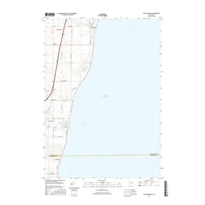
2016 Map of Cleveland East
USGS Topo · Published 2016About this map
Lake Michigan defines the eastern boundary of this Manitowoc County landscape, where small coastal settlements are connected by a network of rural roads. Newton and Northeim occupy the northern reaches, while Cleveland sits further south near the Manitowoc and Sheboygan county line. The terrain is deeply influenced by the hydrography of the Lakeshore Basin, featuring the Centerville Flowage and numerous waterways like Pine Cr and Fischer Cr that drain toward the lake. For local historians and genealogists, the map identifies specific community landmarks including Saint John Cem near Co Rd F and Kassa Cem further south. This 2016 survey illustrates the persistent agricultural and residential patterns of eastern Wisconsin, where modern thoroughfares like Lakeshore Rd follow the historic contours of the lakefront.
Find a feature on this map
41 named features on this map. Tap any name to fly to it.
Don’t see what you’re looking for? This feature index may not catch every label — zoom into the map to look around manually.
Map Details
Editions of this 2016 Cleveland East Map
This is the sole edition of this map. No revisions or reprints were ever made.
Other maps of this area

1954 · Manitowoc
USGS Topo · 1:62,500

1954 · Cleveland
USGS Topo · 1:24,000

1954 · St. Wendel
USGS Topo · 1:24,000

1954 · Sheboygan North
USGS Topo · 1:62,500

1954 · Sheboygan North
USGS Topo · 1:24,000

1954 · Howards Grove
USGS Topo · 1:62,500

1954 · Howards Grove
USGS Topo · 1:24,000

1954 · Reedsville
USGS Topo · 1:62,500

1954 · Manitowoc
USGS Topo · 1:24,000

1954 · Milwaukee
USGS Topo · 1:250,000