
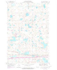
1954 Map of Cleveland NW
USGS Topo · Published 1956About this map
Glacial prairie potholes and scattered wetlands define this section of central North Dakota, mapped shortly after the turn of the mid-century. The Northern Pacific railroad cuts a straight east-west line across the southern portion of the quadrangle, serving as the primary anchor for local development. This rail corridor established the town of Cleveland, which sits at the southeastern edge of the survey. Beyond the settled area, the landscape is divided into townships such as Iosco, Valley Spring, and Flint, characterized by a dense network of sloughs and basins including Runner Slough. For local historians and genealogists, the map preserves the location of the Homes Cem and a prominent Radio Tower, reflecting the era's rural infrastructure and community markers in a period of agricultural stability.
Find a feature on this map
11 named features on this map. Tap any name to fly to it.
Don’t see what you’re looking for? This feature index may not catch every label — zoom into the map to look around manually.
Map Details
Editions of this 1954 Cleveland NW Map
2 editions found
Other maps of this area

1952 · New Rockford
USGS Topo · 1:250,000

1953 · Jamestown
USGS Topo · 1:250,000

1953 · Cleveland SE
USGS Topo · 1:24,000

1953 · Cleveland
USGS Topo · 1:24,000

1953 · Cleveland SW
USGS Topo · 1:24,000

1954 · Medina
USGS Topo · 1:24,000

1955 · Medina SE
USGS Topo · 1:24,000

1956 · New Rockford
USGS Topo · 1:250,000

1956 · Jamestown
USGS Topo · 1:250,000
1958 · Goldwin SE
USGS Topo · 1:24,000