
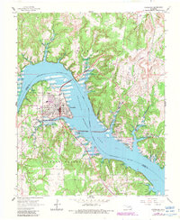
1966 Map of Cleveland
USGS Topo · Published 1967About this map
Cleveland sits at a strategic bend where the Arkansas River meets the expanding Keystone Reservoir, reflecting a landscape transformed by mid-century water management. The town's industrial character is marked by a large Refinery and the crossing of the Missouri Kansas Texas railroad, which bridges the reservoir toward the community of Osage. An Indian Reservation Boundary runs through the water, separating Pawnee and Osage counties and highlighting the complex jurisdictional history of this Oklahoma region.
Find a feature on this map
31 named features on this map. Tap any name to fly to it.
Don’t see what you’re looking for? This feature index may not catch every label — zoom into the map to look around manually.
Map Details
Editions of this 1966 Cleveland Map
2 editions found
Other maps of this area

1912 · Hominy
USGS Topo · 1:125,000

1915 · Hominy
USGS Topo · 1:125,000

1915 · Hominy
USGS Topo · 1:62,500

1929 · Yale
USGS Topo · 1:62,500

1929 · Skedee
USGS Topo · 1:62,500

1931 · Skedee
USGS Topo · 1:62,500

1932 · Yale
USGS Topo · 1:62,500

1955 · Enid
USGS Topo · 1:250,000

1958 · Enid
USGS Topo · 1:250,000

1958 · Keystone Dam
USGS Topo · 1:24,000