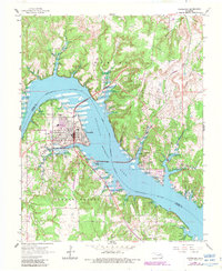
1966 Map of Cleveland
USGS Topo · Published 1983About this map
Cleveland sits at the heart of this landscape, its urban grid tightly defined by the curving banks of the Arkansas River and the expanding waters of Keystone Lake. This era shows the community at a crossroads of industrial and recreational activity, marked by the presence of a refinery and the Cleveland Municipal Airport. Across the water, the settlement of Osage and the Osage Indian Reservation Boundary emphasize the complex jurisdictional history of the region. The map highlights the area's extraction history through the Boston Oil Field and Lauderdale Field, while several local burial grounds like Woodland Cemetery and Bear Creek Cem provide essential data points for family historians. The purple revisions on this edition track the evolving shoreline of the lake and the development of Osage Point Park, reflecting the mid-century transformation of the river valley.
Find a feature on this map
29 named features on this map. Tap any name to fly to it.
Don’t see what you’re looking for? This feature index may not catch every label — zoom into the map to look around manually.
Map Details
Editions of this 1966 Cleveland Map
2 editions found

Other maps of this area

1912 · Hominy
USGS Topo · 1:125,000

1915 · Hominy
USGS Topo · 1:125,000

1915 · Hominy
USGS Topo · 1:62,500

1929 · Yale
USGS Topo · 1:62,500

1929 · Skedee
USGS Topo · 1:62,500

1931 · Skedee
USGS Topo · 1:62,500

1932 · Yale
USGS Topo · 1:62,500

1955 · Enid
USGS Topo · 1:250,000

1958 · Enid
USGS Topo · 1:250,000

1958 · Keystone Dam
USGS Topo · 1:24,000