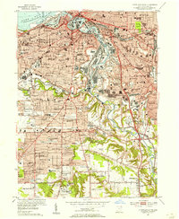
1953 Map of Cleveland South
USGS Topo · Published 1955About this map
The Cuyahoga River meanders through a dense industrial and residential landscape in the early 1950s, defining the character of South Cleveland and its neighboring suburbs. This era shows the heavy influence of the rail-to-river economy, with major lines like the Erie, Baltimore and Ohio, and New York Central converging near the Union Terminal and the complex industrial corridor of the Turning Basin. The map reveals the neighborhood-centric development of the period, marked by a high concentration of parochial and public institutions such as Lourdes Academy, St Ignatius College, and St Stanislaus Novitiate. This social fabric is further detailed through dozens of community landmarks, from the Cleveland Zoological Park in Brookside Park to historic burial grounds including Woodland Cemetery and the Riverside Cemetery. The expansion of the postwar road network is evident in the paths of the Memorial Shoreway and Willow Freeway.
Find a feature on this map
101 named features on this map. Tap any name to fly to it.
Don’t see what you’re looking for? This feature index may not catch every label — zoom into the map to look around manually.
Map Details
Editions of this 1953 Cleveland South Map
This is the sole edition of this map. No revisions or reprints were ever made.
Other maps of this area

1901 · Euclid
USGS Topo · 1:62,500

1902 · Berea
USGS Topo · 1:62,500

1903 · Cleveland
USGS Topo · 1:62,500

1903 · Euclid
USGS Topo · 1:62,500

1904 · Berea
USGS Topo · 1:62,500

1950 · Cleveland
USGS Topo · 1:250,000

1953 · Shaker Heights
USGS Topo · 1:24,000

1953 · Broadview Heights
USGS Topo · 1:24,000

1953 · Berea
USGS Topo · 1:24,000

1953 · East Cleveland
USGS Topo · 1:24,000