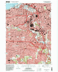
1994 Map of Cleveland South
USGS Topo · Published 2000About this map
Industrial corridors and residential growth converge along the Cuyahoga River in this late twentieth-century record of the Cleveland metro area. The map illustrates the massive scale of the river's Turning Basin and the concentration of Ore Docks near the Lake Erie shoreline, underscoring the city's legacy as a major Great Lakes port. To the south, the landscape shifts toward suburban expansion in Parma and Brooklyn Heights, where large-scale shopping centers like Biddulph Plaza Shopping Center appear alongside historic landholdings such as the Stearns Homestead.
Find a feature on this map
145 named features on this map. Tap any name to fly to it.
Don’t see what you’re looking for? This feature index may not catch every label — zoom into the map to look around manually.
Map Details
Editions of this 1994 Cleveland South Map
This is the sole edition of this map. No revisions or reprints were ever made.
Other maps of this area

1901 · Euclid
USGS Topo · 1:62,500

1902 · Berea
USGS Topo · 1:62,500

1903 · Cleveland
USGS Topo · 1:62,500

1903 · Euclid
USGS Topo · 1:62,500

1904 · Berea
USGS Topo · 1:62,500

1950 · Cleveland
USGS Topo · 1:250,000

1953 · Shaker Heights
USGS Topo · 1:24,000

1953 · Broadview Heights
USGS Topo · 1:24,000

1953 · Berea
USGS Topo · 1:24,000

1953 · East Cleveland
USGS Topo · 1:24,000