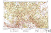
1954 Map of Clifton
USGS Topo · Published 1974About this map
Clifton serves as a primary hub in this mid-century survey of the high desert and mountain country straddling the Arizona and New Mexico border. The landscape is defined by the massive escarpment of the Mogollon Rim and the Mogollon Mountains, with the Continental Divide winding through the eastern portion of the sheet. Settlements like San Francisco Plaza, Alma, and Glenwood are linked by the winding courses of the San Francisco River and the Gila River. This era shows a region dominated by vast federal lands, including the Apache National Forest and the Gila Wilderness Area, where the rugged terrain transitions from the high San Agustin Plains to the deep river canyons. The presence of Fort Thomas and various mines near the Southern Pacific railroad line indicates the historical importance of both military outposts and mineral extraction to the local economy.
Find a feature on this map
55 named features on this map. Tap any name to fly to it.
Don’t see what you’re looking for? This feature index may not catch every label — zoom into the map to look around manually.
Map Details
Editions of this 1954 Clifton Map
3 editions found

Other maps of this area

1886 · St Johns
USGS Topo · 1:250,000

1886 · Holbrook
USGS Topo · 1:250,000

1892 · St Johns
USGS Topo · 1:250,000

1893 · Holbrook
USGS Topo · 1:250,000

1902 · Clifton
USGS Topo · 1:62,500

1909 · Silver City
USGS Topo · 1:125,000

1910 · Mogollon
USGS Topo · 1:125,000

1911 · Alum Mountain
USGS Topo · 1:125,000

1912 · Mogollon
USGS Topo · 1:125,000

1913 · Alum Mountain
USGS Topo · 1:125,000