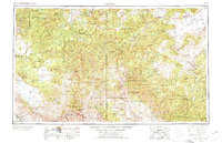
1954 Map of Clifton
USGS Topo · Published 1974About this map
The Morenci Mine dominates the industrial landscape of the high desert, where the copper-rich corridor of eastern Arizona meets the mountainous New Mexico border. This mid-century survey illustrates the intense concentration of mining activity near Clifton and Morenci, serviced by the Southern Pacific RR. Beyond the industrial centers, the map reveals the transition into the preserved landscapes of the Apache National Forest and the Gila Wilderness. Settlement patterns follow the river valleys, with small communities like Luna, Reserve, and Glenwood clustered along the San Francisco River and Tularosa River. The map is particularly useful for identifying the relative positions of high peaks such as Mount Baldy and Whitewater Baldy against the distinct topography of the Mogollon Rim, providing a clear view of the region before modern development expanded into the backcountry.
Find a feature on this map
61 named features on this map. Tap any name to fly to it.
Don’t see what you’re looking for? This feature index may not catch every label — zoom into the map to look around manually.
Map Details
Editions of this 1954 Clifton Map
3 editions found

Other maps of this area

1886 · St Johns
USGS Topo · 1:250,000

1886 · Holbrook
USGS Topo · 1:250,000

1892 · St Johns
USGS Topo · 1:250,000

1893 · Holbrook
USGS Topo · 1:250,000

1902 · Clifton
USGS Topo · 1:62,500

1909 · Silver City
USGS Topo · 1:125,000

1910 · Mogollon
USGS Topo · 1:125,000

1911 · Alum Mountain
USGS Topo · 1:125,000

1912 · Mogollon
USGS Topo · 1:125,000

1913 · Alum Mountain
USGS Topo · 1:125,000