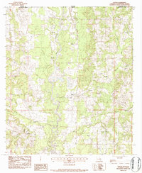
1983 Map of Clifton
USGS Topo · Published 1984About this map
The Bogue Chitto river meanders through this portion of Washington Parish, creating a landscape defined by its waterway and several active extractive sites. In the early 1980s, the local economy was anchored by several Gravel Pits and a Sand and Gravel Pit situated near the riverbanks. The settlement of Clifton serves as a central point, surrounded by a dense network of family cemeteries and rural churches that reflect the area's deep genealogical roots.
Find a feature on this map
43 named features on this map. Tap any name to fly to it.
Don’t see what you’re looking for? This feature index may not catch every label — zoom into the map to look around manually.
Map Details
Editions of this 1983 Clifton Map
This is the sole edition of this map. No revisions or reprints were ever made.
Other maps of this area

1939 · Sunny Hill
USGS Topo · 1:31,680

1939 · Clifton
USGS Topo · 1:31,680

1942 · Thigpen
USGS Topo · 1:31,680

1942 · Wilmer
USGS Topo · 1:31,680

1942 · Thomas
USGS Topo · 1:31,680

1950 · Franklinton
USGS Topo · 1:31,680

1953 · Natchez
USGS Topo · 1:250,000

1954 · Baton Rouge
USGS Topo · 1:250,000

1956 · Natchez
USGS Topo · 1:250,000

1956 · Baton Rouge
USGS Topo · 1:250,000