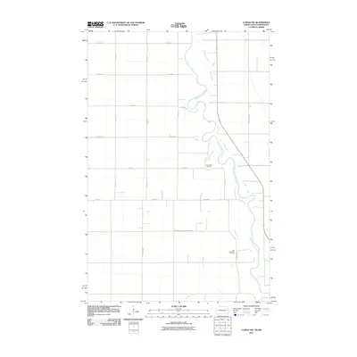
2011 Map of Climax NW
USGS Topo · Published 2011About this map
The Red River of the North winds through this section of the Red River Valley, defining the border between North Dakota and Minnesota. The landscape is dominated by the geometric precision of the township and range system, with gravel roads like Eagle Ave and 5th Ave NE bisecting the vast agricultural plains. The drainage pattern is further defined by the meandering course of Buffalo Coulee, which carves through the flat terrain west of the main river. This map provides a clear look at the rural infrastructure of the early 21st century, showing the boundaries of Stavanger and Belmont No. 52. Genealogists and local historians will find value in the precise location of traditional burial grounds, including Rosendahl Cemetery and North Ringsaker Cemetery, which serve as landmarks within the expansive prairie grid.
Find a feature on this map
19 named features on this map. Tap any name to fly to it.
Don’t see what you’re looking for? This feature index may not catch every label — zoom into the map to look around manually.
Map Details
Editions of this 2011 Climax NW Map
This is the sole edition of this map. No revisions or reprints were ever made.
Other maps of this area

1919 · Eldred
USGS Topo · 1:62,500

1934 · Grand Forks
USGS Topo · 1:62,500

1938 · Grand Forks
USGS Topo · 1:62,500

1952 · Grand Forks
USGS Topo · 1:250,000

1956 · Grand Forks
USGS Topo · 1:250,000

1964 · Climax NW
USGS Topo · 1:24,000

1964 · Climax SW
USGS Topo · 1:24,000
1964 · Climax
USGS Topo · 1:24,000
1964 · Fisher
USGS Topo · 1:24,000
1964 · Bygland
USGS Topo · 1:24,000