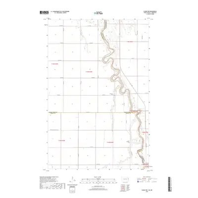
2018 Map of Climax NW
USGS Topo · Published 2018About this map
The Red River of the North winds through this borderland region, defining the winding boundary between North Dakota and Minnesota. This 2018 survey captures the intricate oxbows and floodplains of the river valley where Grand Forks, Polk, and Traill counties meet. The landscape is dominated by a precise grid of agricultural sections and rural roads like Co Hwy 25 and Co Hwy 4, reflecting the deep-rooted farming heritage of the Red River Valley. Local history is anchored by the Rosendahl Cem and North Ringsaker Cem, which serve as quiet markers of the early Scandinavian and pioneer communities that settled these fertile plains. Away from the main river channel, the Buffalo Coulee meanders across the southern sections, while the long stretch of Stavanger and Belmont No 52 highlights the administrative and township divisions that have organized this territory since the late nineteenth century.
Find a feature on this map
33 named features on this map. Tap any name to fly to it.
Don’t see what you’re looking for? This feature index may not catch every label — zoom into the map to look around manually.
Map Details
Editions of this 2018 Climax NW Map
This is the sole edition of this map. No revisions or reprints were ever made.
Other maps of this area

1919 · Eldred
USGS Topo · 1:62,500

1934 · Grand Forks
USGS Topo · 1:62,500

1938 · Grand Forks
USGS Topo · 1:62,500

1952 · Grand Forks
USGS Topo · 1:250,000

1956 · Grand Forks
USGS Topo · 1:250,000

1964 · Climax NW
USGS Topo · 1:24,000

1964 · Climax SW
USGS Topo · 1:24,000
1964 · Climax
USGS Topo · 1:24,000
1964 · Fisher
USGS Topo · 1:24,000
1964 · Bygland
USGS Topo · 1:24,000