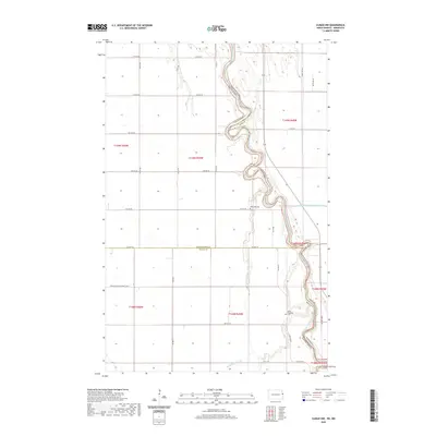
2020 Map of Climax NW
USGS Topo · Published 2020About this map
The Red River of the N (Water) meanders sharply through the heart of the Red River Valley, marking the state boundary between North Dakota and Minnesota. This 2020 survey captures the intensely agricultural landscape across the borders of Grand Forks and Traill Counties, North Dakota, and neighboring Polk County, Minnesota. The land is organized by a strict grid of section roads like 5th Ave NE and Co Hwy 4, designed to support large-scale farming operations in this famously flat terrain. Local history is anchored by rural landmarks such as Rosendahl Cem and North Ringsaker Cem, which stand alongside water management features like Buffalo Coulee and County Ditch Number One Hundred Three. The presence of Stavanger and Belmont No 52 reflects the township-level organization that has defined this rural prairie region for generations.
Find a feature on this map
33 named features on this map. Tap any name to fly to it.
Don’t see what you’re looking for? This feature index may not catch every label — zoom into the map to look around manually.
Map Details
Editions of this 2020 Climax NW Map
This is the sole edition of this map. No revisions or reprints were ever made.
Other maps of this area

1919 · Eldred
USGS Topo · 1:62,500

1934 · Grand Forks
USGS Topo · 1:62,500

1938 · Grand Forks
USGS Topo · 1:62,500

1952 · Grand Forks
USGS Topo · 1:250,000

1956 · Grand Forks
USGS Topo · 1:250,000

1964 · Climax NW
USGS Topo · 1:24,000

1964 · Climax SW
USGS Topo · 1:24,000
1964 · Climax
USGS Topo · 1:24,000
1964 · Fisher
USGS Topo · 1:24,000
1964 · Bygland
USGS Topo · 1:24,000