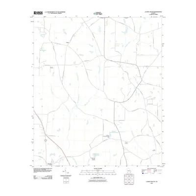
2011 Map of Climax South
USGS Topo · Published 2011About this map
Attapulgus serves as the primary hub in this southwest Georgia landscape, positioned near the intersection of the Tallahassee Hwy and Wautauga Rd. The region is defined by a dense network of watercourses, with Attapulgus Creek and its many tributaries, such as Yellow Water Branch and Callahan Branch, carving through the agricultural terrain. To the north, the small settlement of Otisco sits at the junction of Attapulgus Climax Rd and Lake Douglas Rd.
Find a feature on this map
52 named features on this map. Tap any name to fly to it.
Don’t see what you’re looking for? This feature index may not catch every label — zoom into the map to look around manually.
Map Details
Editions of this 2011 Climax South Map
This is the sole edition of this map. No revisions or reprints were ever made.
Other maps of this area

1954 · Tallahassee
USGS Topo · 1:250,000

1955 · Bainbridge
USGS Topo · 1:62,500

1955 · Whigham
USGS Topo · 1:62,500

1956 · Havana North
USGS Topo · 1:24,000

1956 · Dogtown
USGS Topo · 1:24,000

1956 · Calvary
USGS Topo · 1:24,000

1959 · Tallahassee
USGS Topo · 1:250,000

1960 · Tallahassee
USGS Topo · 1:250,000
1974 · Bainbridge
USGS Topo · 1:24,000
1974 · Fowlstown
USGS Topo · 1:24,000