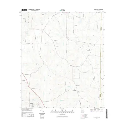
2014 Map of Climax South
USGS Topo · Published 2014About this map
Attapulgus and the surrounding Decatur County agricultural lands are documented here in detail, showcasing a landscape defined by its creek systems and rural cemeteries. The area is anchored by the settlement of Attapulgus in the south and Climax at the northern edge, with the community of Otisco situated along Lake Douglas Rd. The terrain is characterized by gentle elevations like Curry Hill and a network of water bodies including Dubarco Incorporated Lake and Coastal Loan Company Lake.
Find a feature on this map
82 named features on this map. Tap any name to fly to it.
Don’t see what you’re looking for? This feature index may not catch every label — zoom into the map to look around manually.
Map Details
Editions of this 2014 Climax South Map
This is the sole edition of this map. No revisions or reprints were ever made.
Other maps of this area

1954 · Tallahassee
USGS Topo · 1:250,000

1955 · Bainbridge
USGS Topo · 1:62,500

1955 · Whigham
USGS Topo · 1:62,500

1956 · Havana North
USGS Topo · 1:24,000

1956 · Dogtown
USGS Topo · 1:24,000

1956 · Calvary
USGS Topo · 1:24,000

1959 · Tallahassee
USGS Topo · 1:250,000

1960 · Tallahassee
USGS Topo · 1:250,000
1974 · Bainbridge
USGS Topo · 1:24,000
1974 · Fowlstown
USGS Topo · 1:24,000