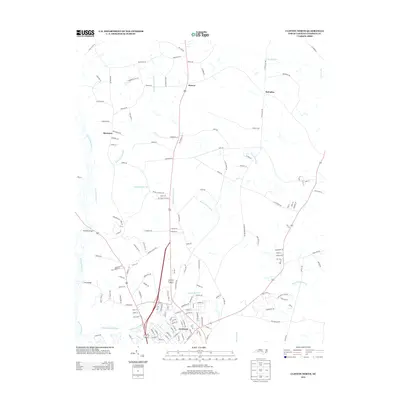
2013 Map of Clinton North
USGS Topo · Published 2013About this map
Clinton anchors the southern portion of this landscape, where the urban street grid meets the winding hydrological networks of Sampson County. The area is defined by a series of significant watercourses and wetlands, including the expansive Beaverdam Swamp and the meandering Great Coharie Cr. These natural drainages dictated the historical placement of crossings like Stevens Bridge and New Bridge, as well as the siting of early industrial points such as Williams Old Mill Br. Beyond the town center, smaller settlements like Keener, McCullen, and Basstown mark the rural intersections that have long supported the county's agricultural character. The map reveals how the modern road network, including routes like Ponderosa Ln and Hargrove Rd, follows the higher ground between swampy lowlands like Gilmore Swamp and Hoe Swamp, illustrating the persistent influence of the coastal plain's hydrology on local development.
Find a feature on this map
154 named features on this map. Tap any name to fly to it.
Don’t see what you’re looking for? This feature index may not catch every label — zoom into the map to look around manually.
Map Details
Editions of this 2013 Clinton North Map
This is the sole edition of this map. No revisions or reprints were ever made.
Other maps of this area

1909 · Coharie
USGS Topo · 1:62,500

1953 · Florence
USGS Topo · 1:250,000

1953 · Raleigh
USGS Topo · 1:250,000

1954 · Florence
USGS Topo · 1:250,000

1954 · Raleigh
USGS Topo · 1:250,000

1959 · Garland
USGS Topo · 1:62,500

1962 · Rose Hill
USGS Topo · 1:62,500

1975 · Faison
USGS Topo · 1:24,000
1978 · Dobbersville
USGS Topo · 1:24,000

1982 · Elizabethtown
USGS Topo · 1:100,000