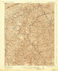
1915 Map of Clintwood
USGS Topo · Published 1931About this map
Pine Mountain forms a natural northwestern barrier for this corner of the Cumberland Plateau, where the early 20th-century landscape is defined by a dense network of mountain schools and river-valley settlements. The county seat of Clintwood sits atop a ridge between the Cranes Nest River and Pound River, serving as a central hub for scattered communities like Dwale, Stratton, and Smith Corners. This 1912-1913 survey by R.B. Marshall and Frank Sutton reveals an era of localized education, with a schoolhouse in nearly every hollow, including the Twin Branch School, Barts Lick School, and Big Oak School. Along the Russell Fork, the Carolina Clinchfield and Ohio railroad cuts through the terrain near Haysi, marking the growth of industrial transport in a region otherwise dominated by the serpentine paths of the McClure River and its numerous branches.
Find a feature on this map
132 named features on this map. Tap any name to fly to it.
Don’t see what you’re looking for? This feature index may not catch every label — zoom into the map to look around manually.
Map Details
Editions of this 1915 Clintwood Map
3 editions found

Other maps of this area

1886 · Grundy
USGS Topo · 1:125,000

1890 · Whitesburg
USGS Topo · 1:125,000

1890 · Grundy
USGS Topo · 1:125,000

1892 · Grundy
USGS Topo · 1:125,000

1892 · Whitesburg
USGS Topo · 1:125,000

1894 · Estillville
USGS Topo · 1:125,000

1897 · Bristol
USGS Topo · 1:125,000

1902 · Bristol
USGS Topo · 1:125,000

1912 · Pound
USGS Topo · 1:48,000

1913 · Clintwood
USGS Topo · 1:62,500