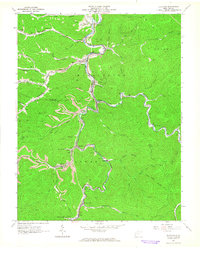
1963 Map of Clothier
USGS Topo · Published 1964About this map
Coal River and the Chesapeake and Ohio railroad line define the industrial and social spine of this Boone and Logan County borderland. Following the narrow valley floors, a string of coal-country settlements including Ottawa, Clothier, and Sharples show the concentrated development typical of the era's mining economy. The Spruce Fork drainage provides the primary corridor for movement between the steep ridges, while smaller communities like Sodom and Dobra occupy the tributary hollows.
Find a feature on this map
67 named features on this map. Tap any name to fly to it.
Don’t see what you’re looking for? This feature index may not catch every label — zoom into the map to look around manually.
Map Details
Editions of this 1963 Clothier Map
3 editions found
Other maps of this area

1891 · Oceana
USGS Topo · 1:125,000

1893 · Oceana
USGS Topo · 1:125,000

1898 · Oceana
USGS Topo · 1:125,000

1899 · Charleston
USGS Topo · 1:125,000

1909 · Peytona
USGS Topo · 1:48,000

1910 · Bald Knob
USGS Topo · 1:48,000

1911 · Peytona
USGS Topo · 1:62,500

1911 · Madison
USGS Topo · 1:62,500

1912 · Bald Knob
USGS Topo · 1:62,500

1913 · Logan
USGS Topo · 1:62,500