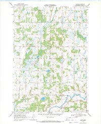
1969 Map of Clotho
USGS Topo · Published 1971About this map
The Long Prairie River meanders through the southeastern corner of this Todd County landscape, defining a region where glacial hydrology shaped the local economy and settlement patterns. The small community of Clotho serves as a central point in a mosaic of wetlands and agricultural tracts, with the extensive Burleene State Wildlife Management Area preserving the area's natural drainage systems. The map reveals a land managed by ditches, such as Ditch No 4 and Ditch No 22, which were essential for reclaiming the lowlands surrounding Eagle Creek and Eagle Valley.
Find a feature on this map
23 named features on this map. Tap any name to fly to it.
Don’t see what you’re looking for? This feature index may not catch every label — zoom into the map to look around manually.
Map Details
Editions of this 1969 Clotho Map
This is the sole edition of this map. No revisions or reprints were ever made.
Other maps of this area

1953 · Brainerd
USGS Topo · 1:250,000

1953 · Saint Cloud
USGS Topo · 1:250,000

1957 · Brainerd
USGS Topo · 1:250,000

1957 · Saint Cloud
USGS Topo · 1:250,000

1958 · Saint Cloud
USGS Topo · 1:250,000

1958 · Brainerd
USGS Topo · 1:250,000

1965 · Brainerd
USGS Topo · 1:250,000

1966 · Lake Osakis East
USGS Topo · 1:24,000
1966 · Clarissa
USGS Topo · 1:24,000
1966 · Browerville SW
USGS Topo · 1:24,000