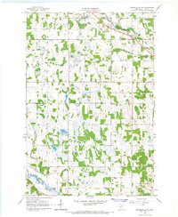
1966 Map of Browerville SW
USGS Topo · Published 1967About this map
The Great Northern railroad corridor serves as a primary artery through this mid-1960s landscape, connecting the agricultural communities of Clarissa and Browerville. The terrain is defined by a dense network of wetlands and small basins, particularly evident within the Iona State Wildlife Management Area. Local infrastructure of the era is well-represented, from the Clarissa Municipal Airfield near Eagle Creek to several rural educational sites like School No 2321.
Find a feature on this map
28 named features on this map. Tap any name to fly to it.
Don’t see what you’re looking for? This feature index may not catch every label — zoom into the map to look around manually.
Map Details
Editions of this 1966 Browerville SW Map
This is the sole edition of this map. No revisions or reprints were ever made.
Other maps of this area

1953 · Brainerd
USGS Topo · 1:250,000

1953 · Saint Cloud
USGS Topo · 1:250,000

1957 · Brainerd
USGS Topo · 1:250,000

1957 · Saint Cloud
USGS Topo · 1:250,000

1958 · Saint Cloud
USGS Topo · 1:250,000

1958 · Brainerd
USGS Topo · 1:250,000

1965 · Brainerd
USGS Topo · 1:250,000
1966 · Browerville
USGS Topo · 1:24,000
1966 · Browerville NE
USGS Topo · 1:24,000
1966 · Long Prairie
USGS Topo · 1:24,000