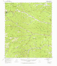
1952 Map of Cloudcroft
USGS Topo · Published 1967About this map
The Sacramento Mountains dominate this 1952 topographic study, showcasing a high-altitude landscape defined by the Lincoln National Forest and its complex system of canyons and springs. High-elevation life is centered at Cloudcroft, where a Ski Tow and Pumphouse point to the area's development as a mountain retreat. The map reveals a network of canyons including Chiquita Canyon and Cienega Canyon, which served as vital corridors for settlement and travel through the timbered heights.
Find a feature on this map
98 named features on this map. Tap any name to fly to it.
Don’t see what you’re looking for? This feature index may not catch every label — zoom into the map to look around manually.
Map Details
Editions of this 1952 Cloudcroft Map
Other maps of this area

1950 · Escondido Canyon
USGS Topo · 1:62,500

1950 · Alamogordo
USGS Topo · 1:62,500

1950 · Mescalero
USGS Topo · 1:62,500

1952 · Cloudcroft
USGS Topo · 1:62,500

1954 · Carlsbad
USGS Topo · 1:250,000

1955 · Roswell
USGS Topo · 1:250,000

1958 · Carlsbad
USGS Topo · 1:250,000

1958 · Roswell
USGS Topo · 1:250,000

1962 · Roswell
USGS Topo · 1:250,000

1963 · Mayhill
USGS Topo · 1:24,000