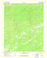
1972 Map of Cloudy
USGS Topo · Published 1973About this map
Kiamichi Mountain and Blackjack Mountain dominate this corner of Pushmataha County, framing a landscape defined by timber and transport. In the early 1970s, the area retained its remote character, centered on the community of Cloudy and its Cloudy Cem. The map reveals a transition from traditional routes like the Harris Trail and Nashoba Trail to industrial infrastructure, most notably the Mc Farland Tram. These tramways were essential for moving timber across the steep slopes of Finley Mountain and Caney Mountain. A dense network of waterways including Cloudy Creek, Mill Creek, and North Brushy Creek dissects the terrain, illustrating the hydrological patterns that shaped local settlement and logging operations in this section of Oklahoma's highlands.
Find a feature on this map
25 named features on this map. Tap any name to fly to it.
Don’t see what you’re looking for? This feature index may not catch every label — zoom into the map to look around manually.
Map Details
Editions of this 1972 Cloudy Map
This is the sole edition of this map. No revisions or reprints were ever made.
Other maps of this area

1901 · Alikchi
USGS Topo · 1:125,000

1950 · Mcalester
USGS Topo · 1:250,000

1962 · McAlester
USGS Topo · 1:250,000

1962 · Sobol
USGS Topo · 1:24,000

1962 · Caney Mountain
USGS Topo · 1:24,000

1965 · McAlester
USGS Topo · 1:250,000

1971 · Spencerville
USGS Topo · 1:24,000
1971 · Rattan
USGS Topo · 1:24,000
1972 · Snow
USGS Topo · 1:24,000
1972 · Wildhorse Mountain
USGS Topo · 1:24,000