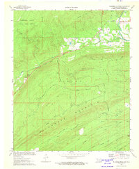
1972 Map of Wildhorse Mountain
USGS Topo · Published 1973About this map
Wildhorse Mountain and Blackjack Mountain dominate this corner of the Choctaw Country, where the landscape is defined by the sharp ridges and deep creek drainages of the Ouachita Mountains. The northern reaches of the map are preserved within the Pushmaтaha County State Game Refuge, while the southern slopes descend toward the winding Brushy Creek and North Brushy Creek. This 1970s survey illustrates a rugged timber and game-focused economy, with isolated settlements like Nashoba and Divide clinging to the valley floors. Genealogists and local historians will find value in the specific locations of the Divide Ch and a small Cem, along with the Cloudy Lookout Tower positioned for fire watch on the high ridges. The map also records the presence of the Alexander Trail and a Shale Pit, reflecting the ongoing balance between natural preservation and rural industry.
Find a feature on this map
28 named features on this map. Tap any name to fly to it.
Don’t see what you’re looking for? This feature index may not catch every label — zoom into the map to look around manually.
Map Details
Editions of this 1972 Wildhorse Mountain Map
This is the sole edition of this map. No revisions or reprints were ever made.
Other maps of this area

1901 · Tuskahoma
USGS Topo · 1:125,000

1901 · Alikchi
USGS Topo · 1:125,000

1908 · Tuskahoma
USGS Topo · 1:125,000

1909 · Tuskahoma
USGS Topo · 1:125,000

1950 · Mcalester
USGS Topo · 1:250,000

1962 · McAlester
USGS Topo · 1:250,000

1962 · Caney Mountain
USGS Topo · 1:24,000

1965 · McAlester
USGS Topo · 1:250,000
1971 · Clayton
USGS Topo · 1:24,000
1971 · Albion SW
USGS Topo · 1:24,000