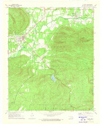
1971 Map of Clayton
USGS Topo · Published 1973About this map
The Kiamichi River valley defines the landscape of southeastern Oklahoma in the early 1970s, where the community of Clayton serves as a local hub. The St Louis - San Francisco railroad runs parallel to the river, connecting the town to Tuskahoma to the northeast. This era shows a clear focus on conservation and recreation, evidenced by the expansive Pushmataha County State Game Refuge and the Clayton Lake State Recreation Area. To the south, the terrain becomes increasingly complex as the Kiamichi Mountains rise, marked by seasonal drainages like Hard Creek and Peal Creek. Local landmarks such as the Landing Strip and Minnetonka Camp reflect the area's mix of rural utility and wilderness access, while the Alexander Trail and Base Line provide historical surveying context for the rugged interior.
Find a feature on this map
30 named features on this map. Tap any name to fly to it.
Don’t see what you’re looking for? This feature index may not catch every label — zoom into the map to look around manually.
Map Details
Editions of this 1971 Clayton Map
This is the sole edition of this map. No revisions or reprints were ever made.
Other maps of this area

1901 · Tuskahoma
USGS Topo · 1:125,000

1901 · Alikchi
USGS Topo · 1:125,000

1908 · Tuskahoma
USGS Topo · 1:125,000

1909 · Tuskahoma
USGS Topo · 1:125,000

1950 · Mcalester
USGS Topo · 1:250,000

1962 · McAlester
USGS Topo · 1:250,000

1965 · McAlester
USGS Topo · 1:250,000

1971 · Yanush
USGS Topo · 1:24,000

1971 · Kiamichi
USGS Topo · 1:24,000
1971 · Sardis
USGS Topo · 1:24,000