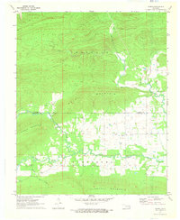
1971 Map of Sardis
USGS Topo · Published 1973About this map
Sardis serves as a central point in this early 1970s survey, situated along the southern edge of the Latimer Co Pushmataha Co line. The landscape is dominated by the ridges of Wolf Mountain and Middle Mountain, while the valleys between are defined by the winding paths of Jackfork Creek and the West Fork Buffalo Creek. A distinct industrial presence is noted near the town center, where Asphalt Pits are marked, indicating the local extraction of natural bitumen resources.
Find a feature on this map
18 named features on this map. Tap any name to fly to it.
Don’t see what you’re looking for? This feature index may not catch every label — zoom into the map to look around manually.
Map Details
Editions of this 1971 Sardis Map
2 editions found
Other maps of this area

1898 · McAlester
USGS Topo · 1:125,000

1901 · Tuskahoma
USGS Topo · 1:125,000

1908 · Tuskahoma
USGS Topo · 1:125,000

1909 · Mc Alester
USGS Topo · 1:125,000

1909 · Tuskahoma
USGS Topo · 1:125,000

1950 · Mcalester
USGS Topo · 1:250,000

1962 · McAlester
USGS Topo · 1:250,000

1965 · McAlester
USGS Topo · 1:250,000

1967 · Hartshorne
USGS Topo · 1:24,000

1971 · Yanush
USGS Topo · 1:24,000