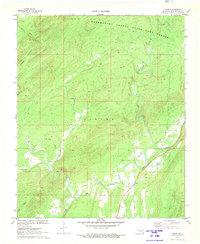
1972 Map of Snow
USGS Topo · Published 1973About this map
Snow Valley and the surrounding timberlands of the Ouachita foothills are defined by the winding drainages of Cedar Creek and Caney Creek in this early 1970s survey. The tiny settlement of Snow serves as a local landmark along the Snow Road, while a portion of the Finley area occupies the central portion of the quadrangle. The map reveals an economy tied to the landscape, featuring a Shale Pit and Minnow Ponds tucked near the valley floor. To the north, the terrain rises sharply toward Dunbar Mountain, and a significant portion of the sheet is dedicated to the Pushmataha County State Game Refuge. This conservation area preserves the character of the upland forest, where Beulah Creek and the West Fork flow through the deep ridges typical of southeastern Oklahoma's interior.
Find a feature on this map
18 named features on this map. Tap any name to fly to it.
Don’t see what you’re looking for? This feature index may not catch every label — zoom into the map to look around manually.
Map Details
Editions of this 1972 Snow Map
This is the sole edition of this map. No revisions or reprints were ever made.
Other maps of this area

1898 · McAlester
USGS Topo · 1:125,000

1901 · Antlers
USGS Topo · 1:125,000

1901 · Tuskahoma
USGS Topo · 1:125,000

1901 · Alikchi
USGS Topo · 1:125,000

1908 · Tuskahoma
USGS Topo · 1:125,000

1909 · Mc Alester
USGS Topo · 1:125,000

1909 · Tuskahoma
USGS Topo · 1:125,000

1912 · Antlers
USGS Topo · 1:125,000

1925 · Antlers
USGS Topo · 1:125,000

1950 · Mcalester
USGS Topo · 1:250,000