
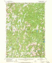
1962 Map of Cloverdale
USGS Topo · Published 1964About this map
Nemadji State Forest and the St Croix State Forest dominate this mid-century landscape in eastern Pine County. The settlement patterns of the early 1960s are visible through small rural centers like Cloverdale and Duxbury, alongside established community landmarks such as Danforth Sch and the Sand Creek Chapel. Transport and industry are marked by the Great Northern railroad corridor in the northwest, which provided a vital link through the townships of Norman and Partridge. The map reveals a complex network of wetlands and water bodies, including Tamarack Lake and the marshy expanses of Thunder Meadows. Local landmarks such as the Eaglehead Lookout Tower and Askov Lookout Tower indicate the importance of forest fire monitoring during this era, while scattered cemeteries like Danforth Cem and Clover Cem offer specific locations for genealogical research in this heavily forested region of Minnesota.
Find a feature on this map
54 named features on this map. Tap any name to fly to it.
Don’t see what you’re looking for? This feature index may not catch every label — zoom into the map to look around manually.
Map Details
Editions of this 1962 Cloverdale Map
2 editions found
Other maps of this area

1949 · Danbury
USGS Topo · 1:48,000

1949 · Holyoke
USGS Topo · 1:48,000

1950 · Webster
USGS Topo · 1:48,000

1950 · Grantsburg
USGS Topo · 1:48,000

1953 · Duluth
USGS Topo · 1:250,000

1953 · Stillwater
USGS Topo · 1:250,000

1955 · Webster
USGS Topo · 1:62,500

1955 · Stillwater
USGS Topo · 1:250,000

1958 · Stillwater
USGS Topo · 1:250,000

1958 · Duluth
USGS Topo · 1:250,000