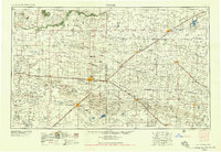
1958 Map of Clovis
USGS Topo · Published 1958About this map
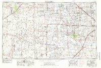
Clovis stands as a primary railroad and military hub on this mid-century survey of the high plains. The landscape is defined by the sharp escarpment of The Caprock to the northwest and the expansive Sand Hills to the south, while the regional economy is anchored by the Atchison Topeka and Santa Fe RR and its various spurs. The map documents the significant presence of Clovis Air Force Base and an adjacent Gunnery Range, illustrating the strategic importance of the Llano Estacado during the Cold War era.
Find a feature on this map
71 named features on this map. Tap any name to fly to it.
Don’t see what you’re looking for? This feature index may not catch every label — zoom into the map to look around manually.
Map Details
Editions of this 1958 Clovis Map
This is the sole edition of this map. No revisions or reprints were ever made.
Other maps of this area
1930 · Tucumcari
USGS Topo · 1:125,000

1954 · Lubbock
USGS Topo · 1:250,000
1954 · Santa Fe
USGS Topo · 1:250,000
1954 · Fort Sumner
USGS Topo · 1:250,000
1954 · Tucumcari
USGS Topo · 1:250,000
1954 · Amarillo
USGS Topo · 1:250,000
1954 · Plainview
USGS Topo · 1:250,000
1954 · Clovis
USGS Topo · 1:250,000
1954 · Brownfield
USGS Topo · 1:250,000
1955 · Roswell
USGS Topo · 1:250,000