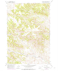
1967 Map of Clubfoot Creek
USGS Topo · Published 1978About this map
The Northern Cheyenne Indian Reservation Boundary defines the southern portion of this landscape, marking a significant transition in land use and jurisdiction within Rosebud County. This 1967 survey reveals a terrain defined by its water sources, where named springs such as B Heart Spring, Rondeau Spring, and Elliot Spring serve as critical landmarks in an otherwise arid drainage basin. The intricate network of waterways, including Clubfoot Creek and Black Eagle Fork, dictates the placement of isolated developments like the Morland Ranch. While much of the area is navigated via a simple Jeep Trail, the map meticulously documents the hydrological features essential to ranching and local habitation, from Mission Creek in the east to the confluence of Cook Creek in the south.
Find a feature on this map
16 named features on this map. Tap any name to fly to it.
Don’t see what you’re looking for? This feature index may not catch every label — zoom into the map to look around manually.
Map Details
Editions of this 1967 Clubfoot Creek Map
2 editions found
Other maps of this area

1954 · Hardin
USGS Topo · 1:250,000

1957 · Hardin
USGS Topo · 1:250,000

1958 · Hardin
USGS Topo · 1:250,000

1958 · Fisher Butte
USGS Topo · 1:24,000

1958 · Lame Deer
USGS Topo · 1:24,000

1958 · Hollowwood Creek
USGS Topo · 1:24,000

1966 · Browns Mountain
USGS Topo · 1:24,000

1966 · Birney Day School
USGS Topo · 1:24,000

1967 · Clubfoot Creek
USGS Topo · 1:24,000

1967 · Birney
USGS Topo · 1:24,000