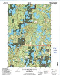
1996 Map of Clubhouse Lake
USGS Topo · Published 1998About this map
The Chippewa National Forest and George Washington State Forest meet in this dense lakeland within Itasca County, defined by a complex network of glacial water bodies and forest management boundaries. This 1996 update, based on topography from 1969 and imagery from 1991, captures a landscape dominated by timber and recreation, centered on the eponymous Clubhouse Lake. The map details various forest service designations and access points, including a notable Organization Camp situated near the water's edge.
Find a feature on this map
66 named features on this map. Tap any name to fly to it.
Don’t see what you’re looking for? This feature index may not catch every label — zoom into the map to look around manually.
Map Details
Editions of this 1996 Clubhouse Lake Map
This is the sole edition of this map. No revisions or reprints were ever made.
Other maps of this area

1919 · Release
USGS Topo · 1:62,500

1919 · Marcell
USGS Topo · 1:62,500

1920 · Trout Lake
USGS Topo · 1:62,500

1943 · Release
USGS Topo · 1:62,500

1954 · Hibbing
USGS Topo · 1:250,000

1957 · Hibbing
USGS Topo · 1:250,000

1958 · Hibbing
USGS Topo · 1:250,000

1964 · Hibbing
USGS Topo · 1:250,000

1970 · Wabana Lake
USGS Topo · 1:24,000

1970 · Clubhouse Lake
USGS Topo · 1:24,000