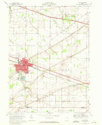
1969 Map of Clyde
USGS Topo · Published 1971About this map
Clyde anchors this northern Ohio landscape where the industrial and agricultural worlds meet along the Norfolk and Western and Penn Central rail lines. The city's residential streets expand near Sucker Run, while the surrounding rural landscape in Green Creek and York townships remains defined by a dense network of family-named cemeteries and small community focal points. Genealogists can trace sites such as McPherson Cemetery, Ellsworth Cem, and the Butternut Ridge Chapel near the Sandusky and Seneca County line.
Find a feature on this map
46 named features on this map. Tap any name to fly to it.
Don’t see what you’re looking for? This feature index may not catch every label — zoom into the map to look around manually.
Map Details
Editions of this 1969 Clyde Map
2 editions found
Other maps of this area

1901 · Bellevue
USGS Topo · 1:62,500

1901 · Fremont
USGS Topo · 1:62,500

1903 · Bellevue
USGS Topo · 1:62,500

1903 · Fremont
USGS Topo · 1:62,500

1906 · Tiffin
USGS Topo · 1:62,500

1915 · Siam
USGS Topo · 1:62,500

1956 · Toledo
USGS Topo · 1:250,000

1957 · Vickery
USGS Topo · 1:24,000
1957 · Wightmans Grove
USGS Topo · 1:24,000
1958 · Fremont East
USGS Topo · 1:24,000