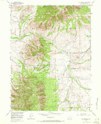
1955 Map of Coad Mountain
USGS Topo · Published 1972About this map
Medicine Bow National Forest dominates the southern half of this mid-century survey, its boundary line cutting across the prominent peaks of Coad Mountain. The high-altitude landscape is defined by a complex drainage network where Oberg Creek and Middle Creek flow westward, while Thode Creek and Pass Creek wind through the eastern valleys. Evidence of early Wyoming ranching life is visible in the placement of the Johnson Ranch and the isolated Ivans Grove, connected by the winding Pass Creek Road. The map provides a detailed view of the transition from the rugged mountain slopes to the more open Loco Bottom Basin. Landform features like Indian Hill and the 9,454-foot summit at Vabm 9454 serve as significant markers for navigating this remote stretch of Carbon County.
Find a feature on this map
35 named features on this map. Tap any name to fly to it.
Don’t see what you’re looking for? This feature index may not catch every label — zoom into the map to look around manually.
Map Details
Editions of this 1955 Coad Mountain Map
3 editions found

Other maps of this area

1893 · Fort Steele
USGS Topo · 1:125,000

1906 · Medicine Bow
USGS Topo · 1:125,000

1908 · Medicine Bow
USGS Topo · 1:125,000

1939 · Saratoga
USGS Topo · 1:125,000

1954 · Rawlins
USGS Topo · 1:250,000

1955 · Coal Bank Basin
USGS Topo · 1:24,000

1955 · Elk Mountain
USGS Topo · 1:24,000

1955 · Elk Mountain SW
USGS Topo · 1:24,000

1955 · Oberg Ranch
USGS Topo · 1:24,000

1955 · Rattlesnake Pass
USGS Topo · 1:24,000