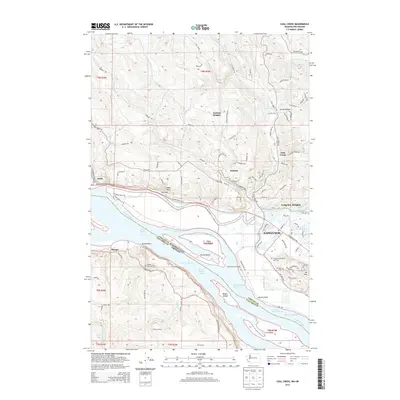
2014 Map of Coal Creek
USGS Topo · Published 2014About this map
The Columbia River serves as the dominant geographic feature of this 2014 survey, bisecting the landscape between Cowlitz County, Washington and Columbia County, Oregon. The northern bank is characterized by the upland neighborhoods of Longview Heights, Eufaula Heights, and Alder Bluff, overlooking a complex system of waterways including Solo Slough and Coal Creek Slough. This modern topography documents the established industrial and residential footprint of Longview alongside rural settlements like Stella and Goose Hollow. On the Oregon side, the riverbank is punctuated by Mayger and Elliott Landing, while the river itself is filled with significant landforms such as Fisher Island and Walker Island. For those tracing local history, the map specifically identifies the Longview Memorial Park Cem, Mt Solo Cem, and the Mayger Downing Cem, providing precise locations for these genealogical landmarks.
Find a feature on this map
116 named features on this map. Tap any name to fly to it.
Don’t see what you’re looking for? This feature index may not catch every label — zoom into the map to look around manually.
Map Details
Editions of this 2014 Coal Creek Map
This is the sole edition of this map. No revisions or reprints were ever made.
Other maps of this area

1919 · Mayger
USGS Topo · 1:62,500

1921 · Kalama
USGS Topo · 1:62,500

1941 · Olequa
USGS Topo · 1:62,500

1941 · Clatskanie
USGS Topo · 1:62,500

1952 · Clatskanie
USGS Topo · 1:62,500

1953 · Hoquiam
USGS Topo · 1:250,000

1953 · Castle Rock
USGS Topo · 1:62,500

1953 · Ryderwood
USGS Topo · 1:62,500

1953 · Rainier
USGS Topo · 1:24,000
1953 · Kelso
USGS Topo · 1:24,000