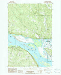
1985 Map of Coal Creek
USGS Topo · Published 1986About this map
The Columbia River forms the central boundary of this landscape, separating the rugged timberlands of Cowlitz County, Washington, from the lowland farms of Columbia County, Oregon. On the northern bank, the residential expansion of Longview pushes westward into the hills, while high elevations like Eufaula Heights and Alder Bluff look down upon the intricate sloughs and islands of the river. Small riverfront communities such as Stella and Mayger are connected by the historic Burlington Northern railroad corridor, reflecting an era where the river and rail were the primary arteries of local commerce.
Find a feature on this map
54 named features on this map. Tap any name to fly to it.
Don’t see what you’re looking for? This feature index may not catch every label — zoom into the map to look around manually.
Map Details
Editions of this 1985 Coal Creek Map
This is the sole edition of this map. No revisions or reprints were ever made.
Other maps of this area

1919 · Mayger
USGS Topo · 1:62,500

1921 · Kalama
USGS Topo · 1:62,500

1941 · Olequa
USGS Topo · 1:62,500

1941 · Clatskanie
USGS Topo · 1:62,500

1952 · Clatskanie
USGS Topo · 1:62,500

1953 · Hoquiam
USGS Topo · 1:250,000

1953 · Castle Rock
USGS Topo · 1:62,500

1953 · Ryderwood
USGS Topo · 1:62,500

1953 · Rainier
USGS Topo · 1:24,000
1953 · Kelso
USGS Topo · 1:24,000