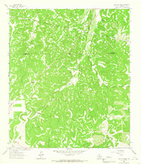
1963 Map of Coal Kiln Draw
USGS Topo · Published 1966About this map
The boundary between Schleicher Co Sutton Co divides this West Texas landscape, dominated by a network of drainage features and private ranch holdings during the early 1960s. The topography is defined by the significant path of Terrett Draw and Coal Kiln Draw, where the seasonal flow of water has shaped the terrain into a complex series of ridges and valleys. Evidence of the local ranching economy is prominent throughout the map, with several named family estates including Pope Ranch, Morales Ranch, and the U X Ranch.
Find a feature on this map
26 named features on this map. Tap any name to fly to it.
Don’t see what you’re looking for? This feature index may not catch every label — zoom into the map to look around manually.
Map Details
Editions of this 1963 Coal Kiln Draw Map
This is the sole edition of this map. No revisions or reprints were ever made.
Other maps of this area

1893 · Fort McKavett
USGS Topo · 1:125,000

1954 · Sonora
USGS Topo · 1:250,000

1958 · Sonora
USGS Topo · 1:250,000

1963 · Buffalo Well
USGS Topo · 1:24,000

1963 · McKegan Draw
USGS Topo · 1:24,000

1963 · Buffalo Well SE
USGS Topo · 1:24,000

1963 · Adams SE
USGS Topo · 1:24,000
1963 · Brokeleg Mountain
USGS Topo · 1:24,000

1963 · McKegan Draw NE
USGS Topo · 1:24,000
1970 · Coralina Ranch
USGS Topo · 1:24,000