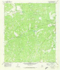
1970 Map of Coralina Ranch
USGS Topo · Published 1973About this map
Coralina Ranch and a series of family-named livestock operations define this West Texas landscape at the turn of the 1970s. The terrain is characterized by the branching drainages of the North Prong Valley and Middle Prong Valley, where water sources like Sixmile Waterhole and Crescent Lake were vital for ranching operations in an arid climate. Significant industrial development is evident in the North Valley Gas Field, supported by an aboveground pipeline and a local Pumping Sta. Small private aircraft facilities, such as the Landing Field near Derrick Ranch, highlight the immense distances of the Edwards Plateau. For genealogists, the Black Cem and several established homesteads like Quemado Ranch and Susch Ranch provide specific points of reference for local families.
Find a feature on this map
28 named features on this map. Tap any name to fly to it.
Don’t see what you’re looking for? This feature index may not catch every label — zoom into the map to look around manually.
Map Details
Editions of this 1970 Coralina Ranch Map
This is the sole edition of this map. No revisions or reprints were ever made.
Other maps of this area

1893 · Fort McKavett
USGS Topo · 1:125,000

1954 · Sonora
USGS Topo · 1:250,000

1958 · Sonora
USGS Topo · 1:250,000

1963 · Buffalo Well
USGS Topo · 1:24,000

1963 · Adams
USGS Topo · 1:24,000

1963 · Adams SE
USGS Topo · 1:24,000
1963 · Coal Kiln Draw
USGS Topo · 1:24,000

1963 · McKegan Draw NE
USGS Topo · 1:24,000
1970 · Fort McKavett NW
USGS Topo · 1:24,000
1970 · Fort McKavett NE
USGS Topo · 1:24,000