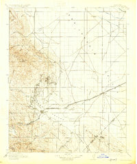
1912 Map of Coalinga
USGS Topo · Published 1925About this map
Coalinga serves as the industrial anchor for this 1912 survey, situated at the base of the Alcalde Hills and Pleasant Valley. The map documents a critical era of resource extraction in Fresno County, marked by the dense networks of development at Oil City and Oilfields nestled against Anticline Ridge. Beyond the petroleum interests, the presence of the San Joaquin Valley Coal Mine near the hills illustrates the diverse mineral wealth being tapped during the early twentieth century.
Find a feature on this map
56 named features on this map. Tap any name to fly to it.
Don’t see what you’re looking for? This feature index may not catch every label — zoom into the map to look around manually.
Map Details
Editions of this 1912 Coalinga Map
4 editions found
Other maps of this area

1912 · Coalinga
USGS Topo · 1:125,000

1913 · Panoche
USGS Topo · 1:125,000

1914 · Lost Hills
USGS Topo · 1:125,000

1914 · Cholame
USGS Topo · 1:125,000

1915 · Priest Valley
USGS Topo · 1:125,000

1915 · Cholame
USGS Topo · 1:125,000

1917 · Cholame
USGS Topo · 1:125,000

1919 · San Miguel
USGS Topo · 1:62,500

1923 · Levis
USGS Topo · 1:31,680

1923 · Englebrecht Ranch
USGS Topo · 1:31,680