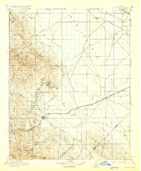
1912 Map of Coalinga
USGS Topo · Published 1930About this map
Oilfields and Oil City dominate the foothills of Anticline Ridge, illustrating the intensive petroleum development in the western San Joaquin Valley during the early 20th century. This landscape is defined by the sharp transition between the rugged Diablo Range peaks like Joaquin Rocks and the industrial activity centered on Coalinga. The map traces the critical Southern Pacific rail line serving the Alcalde Branch, which connected remote mining and drilling outposts to the broader valley markets.
Find a feature on this map
43 named features on this map. Tap any name to fly to it.
Don’t see what you’re looking for? This feature index may not catch every label — zoom into the map to look around manually.
Map Details
Editions of this 1912 Coalinga Map
4 editions found
Other maps of this area

1912 · Coalinga
USGS Topo · 1:125,000

1913 · Panoche
USGS Topo · 1:125,000

1914 · Lost Hills
USGS Topo · 1:125,000

1914 · Cholame
USGS Topo · 1:125,000

1915 · Priest Valley
USGS Topo · 1:125,000

1915 · Cholame
USGS Topo · 1:125,000

1917 · Cholame
USGS Topo · 1:125,000

1919 · San Miguel
USGS Topo · 1:62,500

1923 · Levis
USGS Topo · 1:31,680

1923 · Englebrecht Ranch
USGS Topo · 1:31,680